Barwick Road from Lake Ida Road to L-30 Canal
This page provides project information, updates, and downloadable materials.
- City Project Number: 25-002
- FDOT LAP Project Number: 450793-1-58-01
- FDOT Grant: $2.9M
- CDB Funded: $4.1M
Project Overview
The City of Delray Beach is improving Barwick Road to enhance safety, accessibility, and overall corridor function.
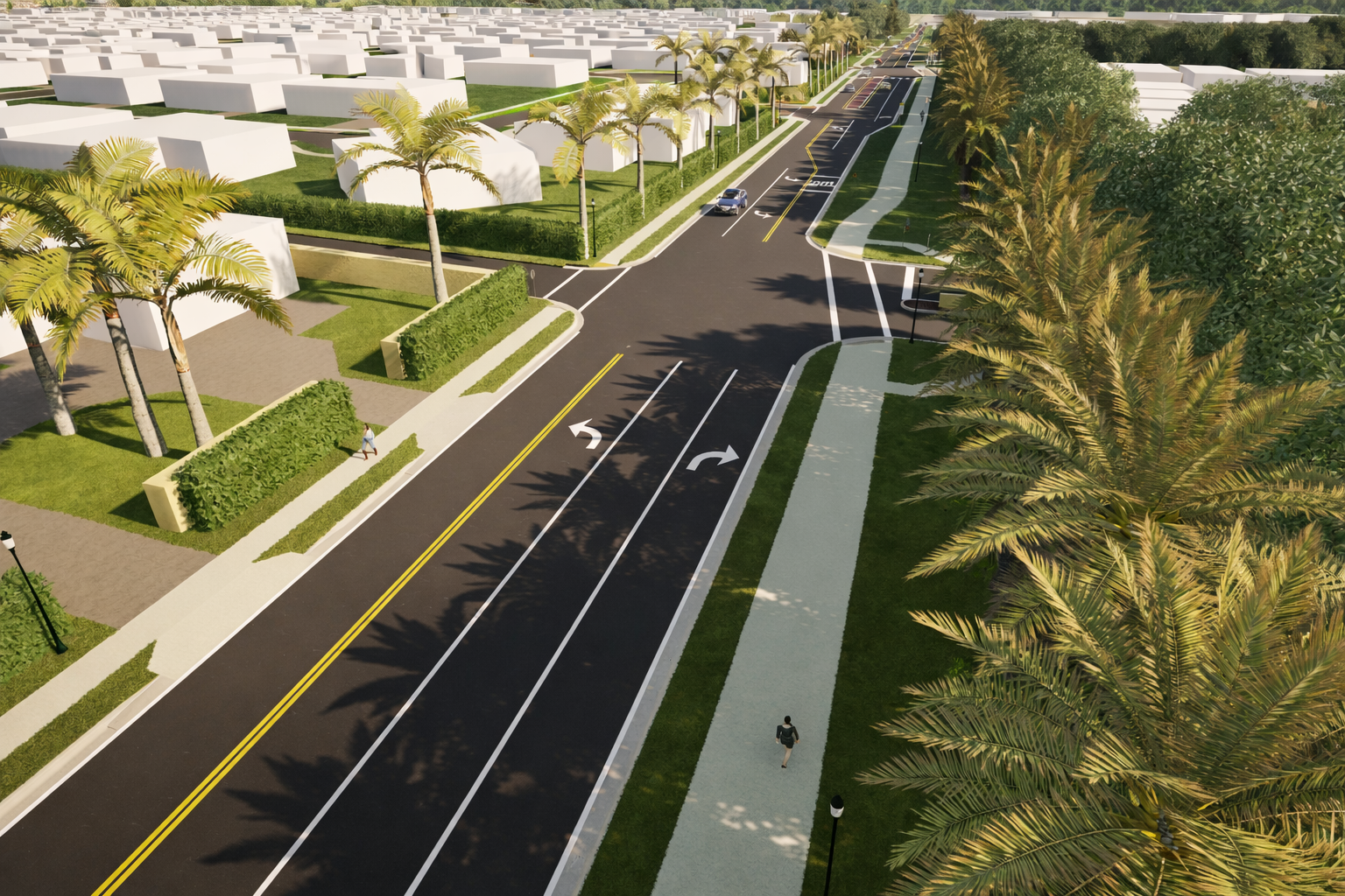
The project limits extend from Lake Ida Road north to the LWDD L-30 Canal. This project is intended to support all users, including motorists, pedestrians, bicyclists, and individuals with disabilities. The intent of these improvements is to ensure the corridor provides a safer and more accessible environment while maintaining efficient traffic operations and accommodating existing and future community needs.
This effort is being completed by the City of Delray Beach in coordination with the Florida Department of Transportation (FDOT) and in accordance with applicable state and local transportation standards. Funding has been awarded through the Metropolitan Planning Organization (MPO) of Palm Beach County to support a portion of the corridor between Lake Ida Road and Sabal Lakes Road as part of the region’s long-range transportation program. The City anticipates pursuing additional funding opportunities to extend the planned improvements farther north to the L-30 Canal and complete the full corridor.
The project follows a Complete Streets approach to improve safety, connectivity, and mobility for residents, commuters, and visitors.




Project Location
Limits shown from Lake Ida Road to the L-30 Canal along Barwick Road.
Project Updates
Sign Up for Project Updates
Subscribe to receive email notifications when new updates or public meeting materials are posted.
Your email will only be used for project communications. You may unsubscribe at any time.
What you will receive
- Public meeting notices
- New materials and downloads
- Milestone announcements
Frequently Asked Questions (FAQs)
Project Basics
1. What are the project limits of the project?
This project extends approximately 0.7 miles along Barwick Road from Lake Ida Road to a point approximately 50 feet south of the Lake Worth Drainage District (LWDD) L-30 Canal right-of-way, within the City of Delray Beach.
2. Why is this project being proposed?
The project is intended to improve safety, mobility, and overall roadway function along Barwick Road, while addressing existing infrastructure deficiencies. Key goals include enhancing accessibility, improving drainage, reducing crashes and injuries, supporting safer pedestrian and bicycle conditions, improving connectivity, reducing traffic conflicts, and extending the long-term life of the roadway pavement.
The project is being developed as a Complete Street, meaning it is designed to safely and comfortably serve all users, including motorists, pedestrians, bicyclists, school-related traffic, and emergency services. A key consideration of the project is also to maintain and, where possible, enhance the natural character and landscaping that residents value, while creating a safer and more reliable corridor for all modes of travel.
3. Why not just mill and resurface the road?
A detailed pavement evaluation found that the existing roadway has reached the end of its service life and is experiencing structural deterioration, including cracking, potholes, and water intrusion into the base course. Milling and resurfacing alone would not correct the underlying issues or provide a long-term solution and could result in premature pavement failures. Even without the proposed Complete Street improvements, roadway reconstruction would still be necessary to address the deteriorating pavement conditions and maintain safe, reliable mobility for the public. As part of the reconstruction process, pedestrian facilities must also be upgraded to meet current safety and accessibility standards.
4. Why are the travel lanes being reduced from 12 feet to 11 feet?
The proposed 11-foot travel lanes follow current urban design guidance. Narrower lanes can help support traffic calming and improve pedestrian and bicycle safety while maintaining normal operations without significantly affecting traffic function. Traffic-calming measures are designed and intended to reduce vehicle speeds while maintaining appropriate access for residents, school traffic, and emergency services.
5. Is this project intended to widen the road and encourage more traffic or growth?
No. The project doesn’t widen the Barwick Road Right-of-Way or increase capacity. It improves safety and multimodal access using Complete Streets principles by enhancing the safety and function of the existing corridor through traffic calming measures and updated roadway design features, not inducing traffic or growth.
6. What is “Complete Streets,” and how does it apply here?
“Complete Streets” is a planning and design approach used by many local governments, including the City of Delray Beach, to ensure that roadways are designed to safely accommodate all users—not just vehicles. This includes motorists, pedestrians, bicyclists, transit users, school-related traffic, and emergency services. For a more in-depth explanation of Complete Streets, click here. The project is being developed as a Complete Street, meaning it is intended to safely and comfortably serve everyone who uses it, including motorists, pedestrians, bicyclists, school-related traffic, and emergency services. A major goal of the project is to maintain, and where possible enhance, the natural character and landscaping that residents value. Where a median is considered, it is being evaluated for safety and access management benefits, as well as its ability to support aesthetic improvements.
Guardrail & Roadside Safety
7. Why is the existing east-side barrier/guardrail proposed to be removed?
A guardrail should be installed only when warranted under accepted engineering standards. Under FHWA, AASHTO, and FDOT guidance, guardrails must be justified through an engineering analysis showing that the barrier would reduce overall crash severity compared to the existing roadside conditions. This study is currently underway, and the results of the study will assist in the evaluation of whether or not the guardrail is warranted to be removed or remain in place.
8. Isn’t the guardrail there to protect children and pedestrians?
Guardrails are not pedestrian-safety devices; they are motorist protection features. National and state standards authorize that barriers are considered hazards unless warranted. Pedestrian safety is being addressed through a broader design approach that includes improved sidewalks, curb separation, visibility enhancements, and traffic calming. An engineering study is currently underway, and the results of the study will assist in the evaluation of whether or not the guardrail is warranted to be removed or remain in place.
9. What standards are being used to make decisions about the guardrail?
Guardrail decisions follow the Federal Highway Administration (FHWA) guidance, the AASHTO Roadside Design Guide, and the Florida Department of Transportation (FDOT) criteria. FHWA states that a guardrail is “a safety barrier intended to shield a motorist who has left the roadway.” FDOT states that roadside barriers “present a hazard in and of themselves” and require a risk-based engineering analysis to determine whether the barrier creates less risk than the feature it would shield. FDOT also requires that this evaluation be completed using recognized methods such as RSAP or the AASHTO Highway Safety Manual. Additionally, an engineering study is currently underway, and the results of the study will assist in the evaluation of whether or not the guardrail is warranted to be removed or remain in place.
Sidewalks, Paths & Roadway Design
10. Why add a sidewalk on the west side of Barwick Road?
This project is being delivered through the Florida Department of Transportation (FDOT) Local Agency Program (LAP) and is partially funded by FDOT. The project has been approved by Palm Beach County and FDOT, and the City Commission has authorized the design to move forward in accordance with current City standards and requirements. As part of accepting FDOT funding, the City is required to design a sidewalk on the west side of Barwick Road to meet applicable safety, accessibility and roadway design criteria.
These requirements include improvements that enhance pedestrian connectivity, reduce the need for mid-block crossings, and provide safer accommodations for all users of the corridor, including pedestrians, bicyclists, motorists, school-related traffic, and emergency services.
11. Why widen the east-side path?
A shared-use path is proposed on the east side. Shared-use paths are intended to serve both pedestrians and cyclists and must be designed with a 10-foot minimum width.
12. Why not add a bike lane instead?
Some stakeholders have suggested bike lanes. The current design reflects multimodal standards and corridor restraints. Bicycle-related concerns will continue to be shared with the City for consideration. Off-street biking facilities are the preferred option for safer travel.
13. Why is a raised median being proposed instead of a continuous center turn lane?
Raised medians reduce conflict points, discourage unsafe passing, and improve access management. Continuous turn lanes can increase crash risk when there are multiple driveways and side-street connections. The design aims to balance safety, access, and traffic operations. The proposed medians will be mountable so that emergency vehicles can drive over them.
Schools, Traffic & Emergency Access
14. Will school pick-up and drop-off traffic be considered?
Yes. Coordination with the PBC School Board is ongoing with Banyan Creek Elementary School and the School District to improve on-site circulation and reduce queuing onto Barwick Road. School-related concerns from the public are part of the future traffic analysis, and any recommendations will be taken under consideration by the School Board for implementation.
15. Will the school crosswalk be moved?
Crosswalk placement is under review based on visibility, pedestrian patterns, and operations. Concerns about crossing complexity have been noted and are being considered in the alternatives review.
16. Will emergency access be affected?
Emergency access is being considered as part of the design process. Coordination with emergency responders is ongoing to ensure response times and access remain acceptable. Emergency access will not be adversely affected.
17. How will construction impact traffic once design is complete?
The completion of the design phase will not directly impact traffic. Traffic impacts may occur during construction as improvements are implemented. The final design will be developed to enhance safety, accessibility, and mobility for all users while minimizing disruptions during construction and supporting efficient traffic operations upon project completion.
18. Will speed limits change?
No. The speed limit will remain the same after the completion of the construction project.
Construction & Property Impacts
19. Will noise impacts be evaluated?
A formal noise study has not been identified as part of the project to date, but comments related to buffering, berming, lane width, and other mitigation ideas will continue to be reviewed as design progresses. There are no anticipated noise impacts anticipated with the construction phase of the project.
20. Will the roadway be closer to homes in some areas?
Certain segments may shift slightly closer to adjacent properties. Specific locations will be reviewed in detail during design. All work on this project will be conducted within the City’s Right-of-Way.
21. Can homeowners request taller walls for noise mitigation?
Requests for walls, on private property, beyond typical heights (e.g., 8-foot variances) should be submitted to the City’s Development Services Department for a permit.
22. How long will the project take?
The design phase is anticipated to be completed in early 2027, with construction expected to begin in summer of 2027. Construction is currently estimated to take approximately 18 months with a completion date of winter 2028/early 2029. All dates are preliminary and subject to change as the project progresses.
23. How is public input being used?
Public comments are documented and shared with the City. Items such as turn lanes, school traffic, buffering, and safety concerns may continue to be evaluated as design and construction progresses.
24. How will drainage be improved?
Drainage improvements will be addressed by either the construction of grass swales along the east and west side of Barwick Road. Enhanced drainage structures will be installed where there are raised curbs and gutters to help reduce localized flooding and improve stormwater flow during heavy rainfall.
25. Will driveways or property access change?
Homeowners will have full access to their driveways and property during the construction phase of the project. Intermittent interruptions will be coordinated ahead of time and homeowners will be given a 30-day and 7-day public notice to plan accordingly.
26. Will trees or landscaping be removed?
The City is committed to preserving existing trees whenever possible during the construction of projects within City limits. Prior to any tree removal, a qualified arborist evaluates affected trees and provides recommendations regarding their health and whether trimming or other measures can allow them to remain in place. In some cases, minor adjustments to the alignment of sidewalks or shared-use paths may be made to help preserve existing trees. However, where tree removal is unavoidable to safely construct the project, the City will follow all applicable regulations and requirements.
27. Will lighting be added or changed?
The City is including the design and construction of pedestrian streetlights on both sides of Barwick Road.
28. Is right-of-way needed for this project?
No. As part of the FDOT Grant all construction work for this project must be within the City’s Right-of-Way.
29. How will utilities be handled?
It is not anticipated that any utilities will be impacted during construction of this project. However, existing sanitary manholes and water valve boxes will be adjusted to match finished grade as part of the improvements. While every effort will be made to avoid utility conflicts, unforeseen conditions may occur during construction. If any utility service disruptions or damages do occur, affected homeowners and utility providers will be promptly notified in accordance with required procedures, and repairs will be coordinated to restore service as quickly as possible.
Point of Contact
Delray Hotline: 561-285-1740
[email protected]Project information is subject to change.